Did you know that Dorset offers some of the best hiking in Southern Vermont ?
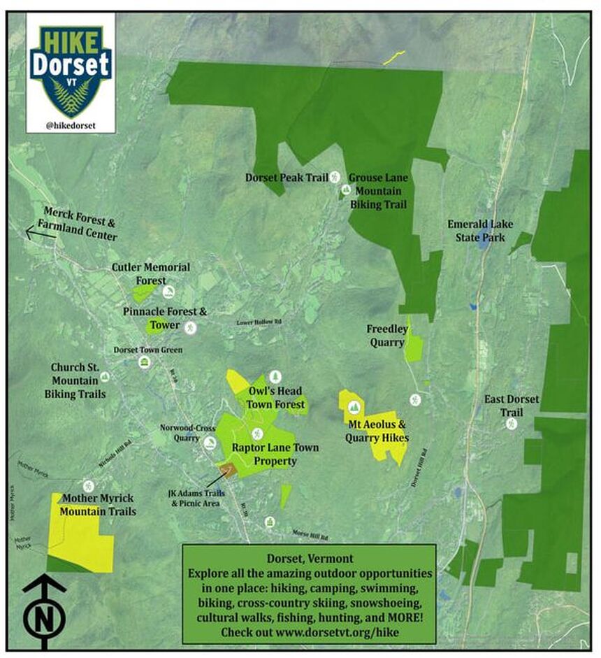
An outdoor enthusiasts dream, Dorset is home to thousands of acres of public and conserved lands that allow for hiking, biking, skiing, horseback riding, the list goes on.
In 2016, the Town of Dorset acquired 260 acres to expand Owls Head Town Forest. The Town has partnered with Vermont Youth Conservation Corps, the Vermont Land Trust, and the Dorset Historical Society to develop a trail network that illustrates the historic, cultural, ecological and recreational values of the Town Forest. The main trail follows an old road up to Gettysburg Quarry and beyond to Owls Head and Gilbert Lookout.
In future years, the Owls Head summit trail will be rebuilt. A long term goal is to connect public lands at Dorset Peak and Emerald Lake State Park to the Town Forest.
Listed below are options for hiking & biking in and around Dorset, get out there and enjoy!

Rachel Batz: Outdoor Recreation Director
Dorset is fortunate to have recently hired Rachel Batz as our Outdoor Recreation Director. Rachel will be in charge of the various recreational properties and opportunities in Dorset, from trail maintenance to guiding users.
Rachel has a degree in Outdoor Recreation & Resource Management from Indiana University and also works as an forester/ arborist. She has experience working for the US Forest Service at Hoosier National Forest, the State of Maine at Baxter State Park in Maine, and has spent time abroad working in the fields of land management and horticulture. Rachel lives on a farm in Salem, NY with her two dogs.
To send Rachel comments or input email: hikedorset@gmail.com
Master Plan - Outdoor Recreation in Dorset:
| Outdoor Recreation Master Plan 2022 |
Owls Head Town Forest - Dorset, Vermont
Directions: The Town Forest Trail Head is located Raptor Lane off Vermont Route 30 in Dorset.
THE KEN'S CAMP ACCESS IS CLOSED,
ALL ACCESS IS VIA RAPTOR LANE
|
| ||||
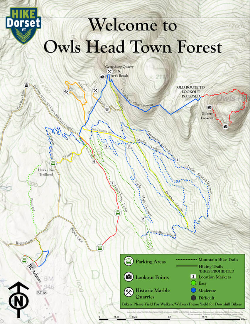
Hike - Bike in Owls Head Town Forest:
|
| ||||
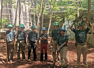
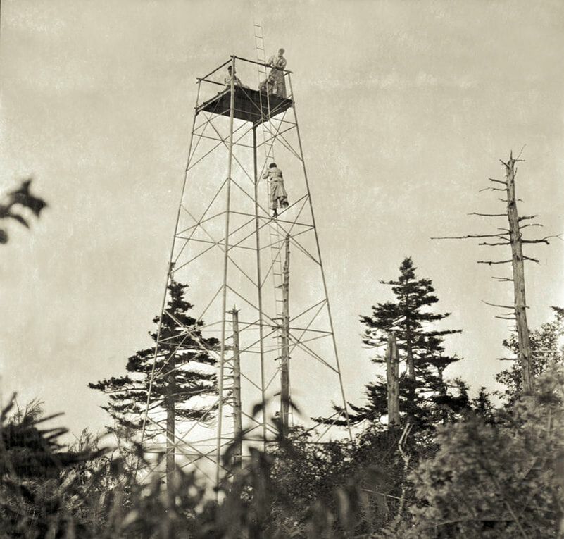
VYCC crew at Gettysburg Quarry
Lower Prince Quarry Hike:
Distance: 0.45 miles Elevation Change: very little Hiking Time: 15-25 minutes Ability Level: easy/intermediate From the Trailhead take the orange on the left. A hike of 0.25 flat easy miles will bring you to the Lower Prince Quarry. Just below the Quarry there is a small view point to the west with the Quarry directly to the east. Lower Prince Quarry: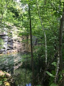
|
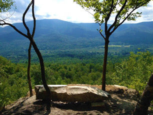
Gettysburg Quarry Hike:
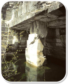
Distance: 0.45 miles Elevation Change: 800' Hiking Time: 40 min./25 min. return Ability Level: Intermediate/Advanced From the Trailhead take the blue trail on the left. A hike of 0.45 miles ascending steadily will bring you to the Quarry. Just before the Quarry is a side trail leading to the Quarry Lookout. Be sure to take a seat on Art's Bench and enjoy the view of Dorset Valley. Art's Bench
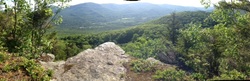
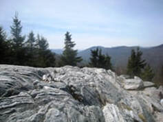
Gilbert Lookout Hike:
Distance: 1.6 miles Elevation Change: 1,260' Hiking Time: 1.75 hrs./1.25 hrs. return Ability Level: Advanced/ Challenging From the Trailhead take the blue trail on the left. Follow the blue trail beyond the Gettysburg Quarry a total of 1.5 miles. Continue on the blue trail, the trail turns left enters up a gully then along a flat just before Owls Head. Turn right at the next sign and follow the path with a steep zig zag climb up the ledges another .10 miles. Arrive at Gilbert Lookout, an outcropping of rock with views as far as the Adirondacks. Be sure to see the Gilbert Lookout plaque that has called the lookout home since 1945. Follow blue trail markers and brown signs to Gilbert Lookout |
Klondike Quarry Hike:
Distance: 1.0 miles
Elevation Change: 800'
Hiking Time: 40 minutes
Ability Level: Intermediate
From the Trailhead take the yellow on the right. This hike heads to the south up a few gentle slopes to a four way intersection, follow the signs and take a left at Santa Claus (seriously). The trail turns north to Klondike Quarry and then up the Gettysburg Quarry. This is an EASIER way to access the Gettysburg area than the blue trail.
OTHER GREAT HIKES IN AND AROUND DORSET!
Cutler Memorial Forest: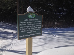
Cutler Memorial Forest, located off Peace Street near the Dorset Village, is a great outdoor location for the public to explore. The property was given to the town in 1976 by Mrs. Isabella Cutler. In the early years walking trails were forged and a bridge was built over the Mettawee River. In recent years the Dorset Conservation Commission has made great improvements to the property: marking trials, creating a parking area, and building a new bridge over the river. A hike around the entire property takes from 35-45 minutes and the trails cover both flat ground and hills. Parking for Cutler Forest is provided at the 393 Peace Street area, and the entire property is easily accessed from this entrance point. We hope shedding light on the property will encourage residents to visit Cutler Forest and enjoy the tranquil experience it offers. Cutler Forest Hike: Distance: 1.0 miles Elevation Change: 100' Hiking Time: 0.25 hrs./0.75 hrs. return Ability level: Easy
|
The Pinnacle: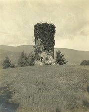
The Pinnacle Tower: In 1910, Miss Cecelia deNottbeck (great grand daughter of John Jacob Astor) had a stone tower built at the top of the hill to replicate a "ruin" from the English landscape. 2010 marked the 100th year that the tower has stood on the hill above Dorset Village. The Pinnacle property consists of a 35 acre forested parcel and an adjacent seven acres situated on a small hill (named The Pinnacle) east of Route 30, north of Dorset Hollow Road and south of Peace Street. Dorset acquired the property in 2005 through the generosity of the late Robert & Margaret Keeler. Pinnacle Hike: Distance: 1.0 miles Elevation Change: 250' Hiking Time: 0.25 hrs./0.75 hrs. return Ability Level: Easy/ Intermediate
| ||||
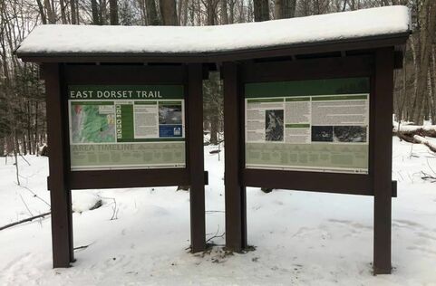
MAD TOM NOTCH TRAIL - EAST DORSET
Mad Tom Notch Hike:
Distance: 4.0 miles
Elevation Change: 1,450'
Hiking Time: 1.25 hrs./3.5 hrs. return
Ability Level: Advanced/ Challenging
The Mad Tom Notch Trail is an official US Forest Service spur trail from the Appalachian & Long Trails. The trail travels up from East Dorset Village to Forest Road 21 in Peru.
The trail travels up through the notch cut by the Mad Tom Brook. The trail leads into a great stretch of the Green Mountain National Forest along the path of an old carriage road that was home to one of the largest lumbering operations in Vermont.
| MAD TOM NOTCH TRAIL MAP & INFO |
DORSET PEAKS
Dorset Peak Hike:
Distance: 3.5 miles (7 total)
Elevation Change: 2,370'
Elevation at Peak: 3,770'
Hiking Time: 4-6 hours
Ability Level: Difficult
Distance: 3.5 miles (7 total)
Elevation Change: 2,370'
Elevation at Peak: 3,770'
Hiking Time: 4-6 hours
Ability Level: Difficult
|
Parking for Dorset Peak Trail is at the end of Tower Road accessible via Upper or Lower Hollow Road. Dorset Hollow Road splits into either Lower or Upper Hollow Road 0.9 miles from Rt 30. Tower Road is 2.25 miles off Upper Hollow Road or 2.5 miles off Lower Hollow Road. From the parking area, the blue blazed trail begins going northwest on relatively flat terrain for 1.0 mile. The first mile, though easy walking, has several water crossings that can be challenging depending on the water level: be aware! Once at the old hunting camp a little over a mile into the hike, the terrain becomes increasingly steeper and climbs for the rest of the trail. At 2.0 miles, there is an intersection in the trail--keep right and continue following the blue blazing, traveling east. Continue to a clear wooden sign (at 2.75 miles) with the word TOWER on it. Going to the left (yellow blazes) 0.4 miles will lead to the North Peak where a “Dorset” sign denotes the peak. From the TOWER sign, going to the right (blue blazes) 0.2 miles will lead to the old tower and South Peak, where the best viewpoint is. Please respect the properties by staying on the trail throughout the hike!
|

| ||
Freedley Quarry
Freedley Quarry Hike:
Distance: 1.25 miles
Elevation Change: 500'
Hiking Time: 1-2 hrs. return
Ability Level: Easy/ Moderate
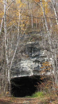
Freedley Quarry was first opened in 1808 and produced the greatest quantity of any Dorset marble. Most of the marble was lowered by means of a mile-long funicular railroad. At 2,040 feet above sea level, Freedley is at one of the highest elevations of any marble quarry in the world. Unlike the open pit quarries prevalent in the area, Freedley tunneled into the mountainside. Please explore carefully and leave only footprints!
Parking for Freedley Quarry is off Dorset Hill Road, 1.9 miles up the road from Morse Hill Road (73.0211662°W, 43.2460710°N). There is a small parking area, but beware during the winter. Parking is limited, please DO NOT park in private driveways or in the traveled way of Dorset Hill Road.
The trail follows an old roadbed north of the parking area past a metal gate. Follow the main roadbed 1.25 miles all the way to the quarry. There are several spur trails along the way, but keep to the main path. There is a lookout just past the quarry that faces east and has views of Mt. Tabor, Bromley Mountain, and East Mountain in Manchester.
Distance: 1.25 miles
Elevation Change: 500'
Hiking Time: 1-2 hrs. return
Ability Level: Easy/ Moderate
Freedley Quarry was first opened in 1808 and produced the greatest quantity of any Dorset marble. Most of the marble was lowered by means of a mile-long funicular railroad. At 2,040 feet above sea level, Freedley is at one of the highest elevations of any marble quarry in the world. Unlike the open pit quarries prevalent in the area, Freedley tunneled into the mountainside. Please explore carefully and leave only footprints!
Parking for Freedley Quarry is off Dorset Hill Road, 1.9 miles up the road from Morse Hill Road (73.0211662°W, 43.2460710°N). There is a small parking area, but beware during the winter. Parking is limited, please DO NOT park in private driveways or in the traveled way of Dorset Hill Road.
The trail follows an old roadbed north of the parking area past a metal gate. Follow the main roadbed 1.25 miles all the way to the quarry. There are several spur trails along the way, but keep to the main path. There is a lookout just past the quarry that faces east and has views of Mt. Tabor, Bromley Mountain, and East Mountain in Manchester.
| FREEDLEY QUARRY MAP |
Haystack Mountain (Pawlet):Haystack Mountain:
Distance: 3.1 miles Elevation Change: 1,125' Hiking Time: 2-3 hrs. return Ability Level: Intermediate/ Advanced Turn right off Route 30 onto Waite Hill Road, park at the designated location on Waite Hill Road. Follow the Friends of Haystack trail to the summit around 1.5 miles one way. Trail is steep in spots. Views are incredible. The summit of Haystack was recently purchased and conserved by the Friends of Haystack and the Vermont Land Trust. Much of the surrounding lands are known as the North Pawlet Hills Natural Area owned by The Nature Conservancy. 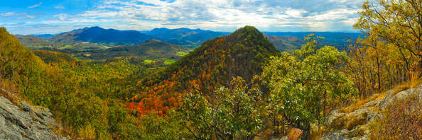
View from Haystack (photo credit: George Bouret) |
Baker Peak & Griffith Lake
Baker Peak - Griffith Lake:
Distance: 6.6 miles Elevation Change: 1,900' - 2,100' Hiking Time: 4-6 hrs. return Ability Level: Intermediate/ Advanced The Lake Trail climbs out of the Otter Creek lowlands and enters Big Branch Wilderness Area on a long switchback that eventually brings one to McGinn Brook. This brook flows out of the spectacular ravine cutting the mountain flank that can be seen from Route 7. At the McGinn Brook crossing, the Baker Peak Trail branches off to the north (left). In just short of a mile, the Baker Peak Trail meets the Appalachian/ Long Trail and ascends over bare ledges, affording fine views of the Otter Creek Valley, Dorset Mountain, and other peaks in the Taconic Mountain Range. The Lake Trail continues east, to Griffith Lake over gradual grades on an old woods road, crossed with small streams. The trail leaves the road, then crests a small hill and reaches the AT/LT junction. Head south (right) to Griffith Lake.
| ||
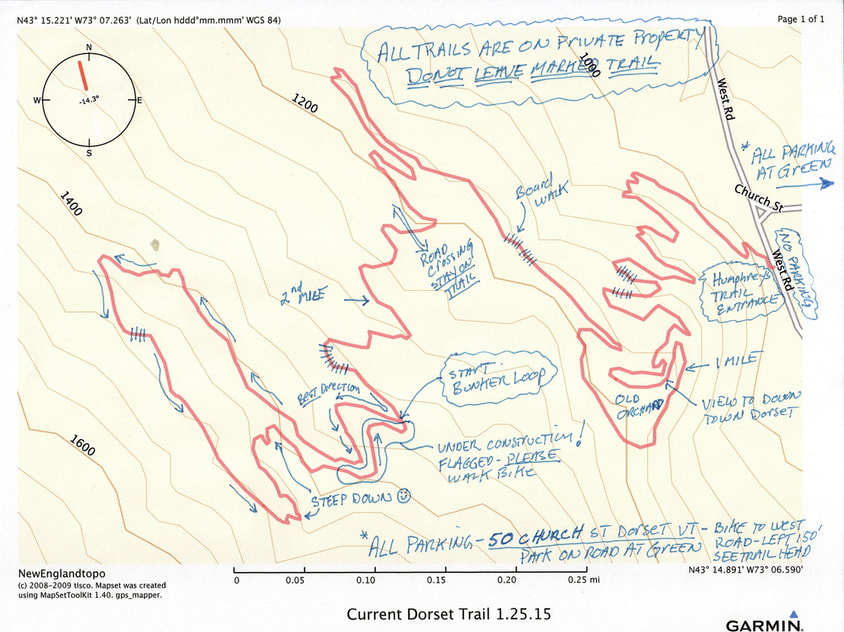
Mountain Biking more your thing? We've got that too!

Northshire Area Trail Systems is a local non-profit group dedicated to creating and improving trail opporuntities in our area. In recent years NATS has focused on building single track mountain bike trail in Dorset. Perhaps the best kept secret in the Northshire is the Humphreys trail off Church Street in Dorset (info below).
Please visit the NATS website and considers becoming a member to support their efforts!
Please visit the NATS website and considers becoming a member to support their efforts!
The Dorset Trails - This is NATS trail network - See trail map below. Park at the Dorset Green on Church Street just off of Rt. 30 in Dorset Vt. Head west along Church Street for 3/10th of a mile to the intersection of the Dorset West Road. Go left (south) for about 150' and look right and see our trail head. The Dorset Trails include two trails - the entry trail Humphreys, which winds up the hill about 2.5 miles and then branches off onto the Bunker loop, which adds another 7/10th of a mile, and reconnects to to Humphreys trail. ALL TRAILS ARE ON PRIVATE PROPERTY - STAY ON MARKED TRAIL. Enjoy!